By: Brian Olson, PE, CFM, CPESC, Senior Water Resources Engineer
Every flood tells a story.
It can reveal aging infrastructure that was not designed for current rainfall patterns or expose assumptions that no longer reflect how watersheds behave.
Floods also tell a more complex story of how infrastructure owners make decisions based on yesterday’s design standards, which no longer guarantee tomorrow’s performance. Because of this, water resources engineers are facing tougher questions than before — such as, how do you prepare infrastructure to withstand increasingly severe and unpredictable conditions?
The answer isn’t simply using more tools, though sophisticated hydrologic and hydraulic modeling play a part in more successful flood mitigation outcomes. The answer is asking the right questions upfront to confirm the selected tools can assist in designing infrastructure for resilience, community safety and long-term asset performance.
We’re listening to what flooding is telling us
In March 2020, the Illinois State Water Survey published updated rainfall amounts for the state. This statistical analysis shows storm events are increasing in intensity and overwhelming drainage and water resources systems. These instances are not specific to Illinois but are applicable nationally and globally as well.
From an anecdotal and data-driven perspective, climate change and the subsequent increases in flood risk will shape infrastructure decisions. We see these challenges across transportation drainage projects, stormwater management and flood mitigation. Our clients need solutions that respond to today’s storm intensities, while also accounting for the possibility of more severe weather events in the future.
At EXP, we utilize sophisticated hydrologic and hydraulic modeling to identify complex flood behavior, evaluate design options and identify practical solutions to help clients and communities prepare.
Evolution of hydrologic & hydraulic (H&H) modeling, its role in flood prevention
Preparing for the unpredictable requires a powerful set of tools. Water resources and drainage engineers have a growing toolbox to evaluate and solve flooding challenges. These include calculation routines, modeling platforms and statistical analyses from state agencies, such as the Illinois State Water Survey and national agencies like the National Oceanic and Atmospheric Administration (NOAA). EXP employs technical engineering judgment, quality analysis of available data and a clear understanding of the problem solved to select the right approach.
A modeling platform, whether used to solve simple or complex problems in one-dimensional or two-dimensions domains, should be treated like a black box, with inputs and outputs that need to be closely analyzed before design can begin. Inputs, such as proper survey information, rainfall depths and intensities and engineering variables represent some of the information required. Our role is to understand what is happening within the model, not simply accept an input-calculation-output routine without evaluating the variables that drive the outcome.
Simple code-based platforms (HEC-1, HEC-2, WSP2) and extensive one and two-dimensional modeling programs can be used to look at flooding issues. Typically, most solutions use a one-dimensional analysis tool to evaluate storm sewers, detention basin sizing and floodplain surface elevation modeling. These can range from spreadsheets to modeling platforms such as HEC-HMS (hydrology), HEC-RAS (hydraulics) and HY-8.
With more complex systems, we must determine if a one-dimensional steady state model is sufficient or whether more advanced analyses and models are needed. Unsteady-state models, such as XP-STORM and HEC-RAS, provide deeper insight into storm sewer networks, detention systems and floodplain hydraulics by capturing dynamic conditions that simpler models cannot. Further down the line are two-dimensional models, SRH 2D and HEC-RAS 2D, which consider incoming hydrology and unsteady state hydraulics to examine flooding extents overlaid on a topographical terrain.
While rare, instances of analysis sometimes call for three-dimensional computational fluid dynamic modeling. As one works from the simple code-based platforms (HEC-1, HEC-2, WSP2) to three-dimensional models, complexity increases at each step, which can result in increased time needed to analyze alternatives and the subsequent budget.
It takes an experienced team of engineers to determine the correct method and model to solve flooding challenges. It also takes a commitment to understanding a client’s problem and formulating a plan of action based on complexity, time and budget.
The right questions for the most effective solution
Deciding which H&H modeling platform to utilize can be daunting. With new program versions released yearly, the technology to analyze flood impacts is constantly evolving.
When working with a reliable and knowledgeable consultant, analysis and design expertise is crucial, but the ability to ask the right questions to develop design criteria and ultimate project goals is even more important. EXP has the capabilities to determine the correct tool for developing effective and resilient water resources solutions. We integrate a wide set of variables to analyze flood prevention options and formulate a tailor-made solution for our clients. We consider:
- Data quality – ensuring input data is correct
- Field validation – reconnaissance of field conditions, which impacts input data
- Calibration – utilizing known flood data to ensure correct results
- Cross-disciplinary integration – working in a team setting with other engineering disciplines to provide a full suite of design services
- Regulatory knowledge – developing solutions that conform to instituted regulations, rules, ordinances and laws
- Engineering judgment – leveraging EXP’s extensive experience and staff knowledge to correctly apply engineering judgment when needed
- Interpretation of results – analyzing the specific modeling tool utilized to correctly determine ultimate design outcomes
Ultimately, a robust modeling platform is only as good as the input data, in addition to the engineer utilizing and interpreting the results. With the appropriate modeling tools, and the technical knowledge, EXP has the formula for delivering a successful, resilient design.
Analysis + design application: Insights from Moline, Illinois
Across North America, EXP applies a defined, data-driven process to help clients evaluate flood risk, establish appropriate design criteria and develop water resources solutions that balance performance, constructability and long-term value.
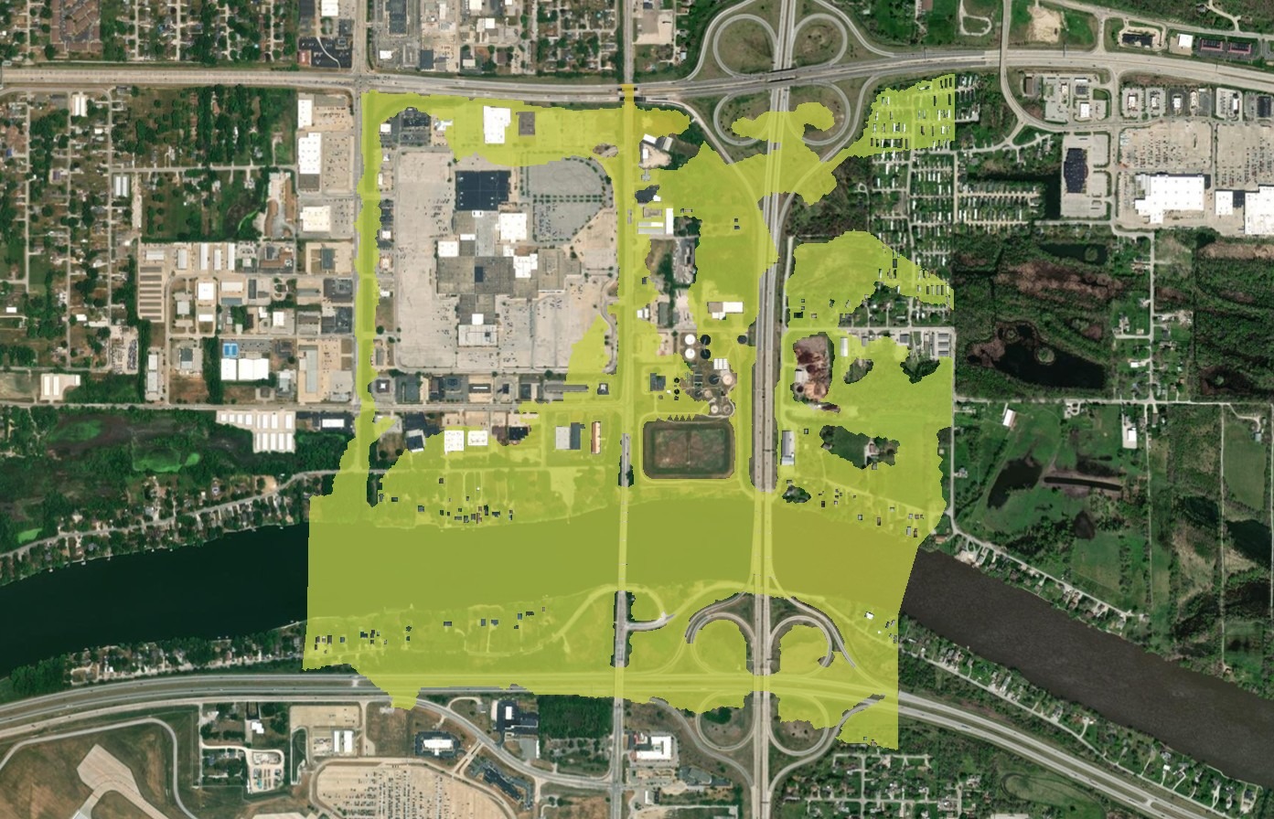
In Moline, a bridge reconstruction project over the Rock River along 27th Street demonstrates how advanced hydraulic analysis can inform infrastructure decisions. The project area sits at the confluence of the Rock River, which flows west, and the 27th Street Tributary, which flows south. . The Illinois Department of Transportation recognized the area’s complexity, from roadway and structural design to the effects of flooding.
EXP worked with IDOT to formulate practical design criteria and the path to achieve maximum results. A two-dimensional model, SRH 2D, was used to look at the overall floodplain within the vicinity of the Rock River and its impact on the 27th Street Tributary to the Rock River.
The results supported scour analysis calculations for the bridge reconstruction, and a look at the tailwater impacts from the Rock River on the 27th Street Tributary. The two-dimensional analysis was utilized in conjunction with a one-dimensional model to specifically investigate tailwater impacts on the 27th Street Tributary. This parallel approach informed design criteria developed in collaboration with IDOT and helped minimize flood impacts while keeping total project cost in mind.
A key takeaway is the importance of a risk-based understanding of storm probability in a given year and its influence on design. This ultimately drives the decision-making process when designing a water resources solution that manages flow while keeping infrastructure investment outcomes in mind.
By helping reduce flood risk to the Rock River and 27th Street Tributary and aligning with client goals, engineers designed a more resilient solution for the present and future. Residents will benefit from reduced flood risk and increased value to not only their property, but daily lives as well.
Resilient infrastructure for tomorrow isn’t built by models alone
Flood resilience will not come from one model, one tool or one solution. It will come from asking better questions, applying hydrologic and hydraulic modeling with discipline and using engineering judgment to turn complex data into infrastructure that protects communities today and adapts to the risks ahead.
EXP is prepared to take on your next project. Contact Senior Water Resources Engineers Brian Olson and Helina Krieger to learn more.